|
Admiralty
Every chart that you buy in the UK contains a huge ‘copyright fee’ within its price. When you buy a paper chart for £21.35 you are handing the Admiralty £15.28 simply for the ‘copyright’ element they claim to own.
On every pack of electronic ‘chart plotter’ charts you buy for say £300, you are handing the Admiralty Charts nearly £200 for the copyright you already own.
In the USA, the government accepts that the original work done to create all their charts was all finished well over 50 years ago, and allows anybody to access charts, in either paper of electronic form, 'Free of Charge'! |
When you arrive in the Mediterranean or the English Channel, at the end of your canal trip, you have very big areas of sea to cruise.
If you have a laptop with CM-93 installed and you buy a little GPS puck receiver from Maplin - http://www.maplin.co.uk.
CM-93will also do the navigation for you.
Display your position on the chart in real-time, display your actual Lat & Long, speed over the ground, ETA and your real time exact position on the chart - exactly like any other chart plotter.
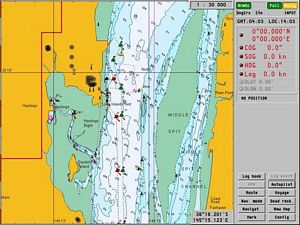
You can sit at home, with the system installed on your laptop, plan your routes and stopping places. If you put your cruising speed, draft etc into its data bank the display will warn you of running aground or simply tell you how many hours it will take to get from waypoint to waypoint or the entire proposed voyage.
Take the laptop to your boat, plug in the GPS puck and you can navigate along the pre-planned route with your position displayed on the chart plus Lat and Long on the side panel...
I came from Australia back to Europe via the Red Sea, using a similar system. It allows you to print out charts, so you are not 100% reliant on electronics, which you should never be.

Courtesy of the American Freedom of information act
it also contains all the NOAA sailing directions for the Mediterranean area.
If you are heading out to the Pacific it has the 12 months of Pacific Ocean Pilot Charts.