|
|
|
SN6North by Canal du Midi
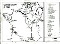
Routes Between the English Channel and the Mediterranean SN6 = South to North via Canal du Midi - Best time March/April to September early October - If your boat has the right draft this is an excellent way to get quickly from the central Mediterranean to the English Channel - Some lovely cruising up the West coast of France and a much easier route than the Portuguese coast or Azores options all to windward...... NOTES ON THE CANAL DU MIDI. Biggest problems Draft - 1.6 metres (5ft 2 inches) MAX! Less in high summer - Width 5.5 metres - (18ft.) Height 3 metres but be warned that the height of 3m is to the centre of the bridge arches - the sides may be as low as 2metres (6ft 5inches) The length of the locks is 30metres (98ft 4inches) So although this can be a good route for many big catamarans with a shallow draft, the width when you add fenders may be a problem.... Also be aware that in mid summer when there is a drought water can be lower than advertised in the Canal du Midi. Unlike the canals in eastern France where you can push your keel though the soft mud the Canal du Midi was blasted out of rock... It is not unknown for boats on the limit to have to be craned out and put on lorries when the level drops in mid summer. At some point you will have to buy a license for the time spent in the river canal system - fairly inexpensive and check on the web site http://www.vnf.fr for info. There are basically 4 entry points to the canal system on the Mediterranean coast of France - Port St Louis, Sete, Port La Nouvelle and Agde - the last two have lower drafts (can be as little as 1.20Ms) than Sete or Port St Louis. If you are heading for the Canal du Midi then Sete is probably best. Go to the yacht club to have your mast very expertly craned down and loaded aboard. Take down your mast and get lots and lots of fenders or rubber tyres to surround you topsides and protect your hull from the rough concrete walls that you will regularly be coming alongside in locks. The tyres should touch the water.... It may be worth making a couple of X's out of wood with a bolt through to support the mast. - there are normally stacks of tyres at the cranes left by boats going the other way. Covering them in plastic rubbish bags secured with lots of sellotape and constantly renewed is helpful in keeping black marks off the hull. You have to get through a railway bridge that only opens morning and evening. This gets you into the Etang de Thau which is buoyed and shallow outside the channel. Into the Canal du Midi - into the Canal lateral de la Garonne onto Bordeaux and the Gironde River. Past Montech, Bezier, Carcassonne, Toulouse and lots of charming villages and towns....
Canal du Midi = My log and some pictures of a recent transit. (SN7) The Scenic Route = My log and some pictures of a recent transit. (SN6) DISTANCE FROM Sete to Bordeaux - 503 Kilometers - 139 locks. Each lock takes between 30 minutes and an hour depending on the situation when you arrive and you can only move in daylight hours! When you get to Bordeaux and re-step the mast, the trip down the river to Royan or straight through the shallows out to sea, requires the appropriate chart or pilot book - the Gironde is a serious river with fast flowing currents. DISTANCE Royan to Falmouth - 355 nautical miles - note: The prevailing winds are out of the north - NNW until you get to the English Channel....... (It is perfectly possible to day sail north from Royan - the only really challenging bits being possibly the Chenal du Four and around the Channel Islands.) You need Navicarte #11 - Canal du Midi - L'Atlantique to Mediterranean. Some canal tips 1. Take off your masthead light, wind vane and vhf antenna - put a bucket over the top of the mast to protect it - they always seem to get bashed. 2. You will need 2 lines to each tyre fender (by law) As you will need as many as possible buy some cheap nylon rope to fix the 'fenders' as you will probably not have enough short lengths in the locker. 3. Keep a knife available in the cockpit just in case one of the mooring lines gets snagged and hangs the boat up as the water goes down in the lock. 4. If you are short handed (only 2) and you have a long enough line - fix a block on the bows and lead the fwd warp through the block and back along the deck to the cockpit - that way who ever is in the cockpit can pull in or let out the lines in the lock if the other one gets stuck on the lock side and is unable to get back on board. 5. You will need a hammer or preferably a mallet to hammer metal spikes into the bank to moor to at night. Frequently keel yachts can only get their bows close to the shore as the rivers/canals frequently shallow at the sides. 6. It may be worth considering having the mast taken by lorry to your destination - Certainly makes the trip easier in terms of moving around the boat. 7. At some point you will have to buy a license for the time spent in the river canal system - fairly inexpensive and check on the official web site http://www.vnf.fr for info. The license is based on the time you intend staying in the waterway system - by day/week/month/year. 8. Under European (and of course French) law anyone operating a boat on the European canal system is required to have a 'boat driving license' as issued by their own country of origin. You can travel in any European river or canal with only the license issued by your own authority. Catch 22 is that the British authorities do not require you to have one! Under the new French 1991 law you need a Certificate of Competence which is issued by the RYA. You may also pass the French test - cat C for boats less than 15m and slower than 20Km/h. Many sea boats do the transit without the certificate. (If you rent a hire boat in France as a Brit you are not required to have a certificate.)
NAVIGATION FEESLicence (Vignette) Fees 2022Navigation fees are simply based on boat length. The vignette certificate should be displayed at the front of the boat, on the starboard side.
|
 click
here for canals chart
click
here for canals chart
|
SN1 = north to south - direct route by sea SN2 = north to south via Canal du Midi SN3 = north to south via Le Havre - Paris - or Calais or St Valery SN4 = south to north via Atlantic coast SN5 = south to north via Azores SN6 = south to north via Canal du Midi SN7 = south to north via canals to Paris and Le Havre or Calais Canal du Midi = My log and some pictures of a recent transit. (SN7) The Scenic Route = My log and some pictures of a recent transit. (SN6) Lorry option = a list of web sites of British and French haulage companies who specalise in boat transport. VNF = Voies Navigables de France - details of license fees and canal offices - official paper http://www.sailtrain.co.uk/CEVNI/images/cevni1.htm This site has a series of tests for the written part of the CEVNI certificate find out if you know the rules! Probably the best site for learning boating things on the net!
These
web sites may be useful for the end of the canal system in the
|
|
|